Why Did Landsat 1’s Experimental Scanner Outlast Its Main Camera?
Landsat 1 began with two competing imaging systems, but an experimental multispectral scanner became the mission’s durable scientific instrument.
Cite this page
“Why Did Landsat 1’s Experimental Scanner Outlast Its Main Camera?” thisDay, thisday.info/history/landsat-1-1972/. Accessed 19 Oct. 2026.
Why Did Landsat 1’s Experimental Scanner Outlast Its Main Camera? (n.d.). thisDay. Retrieved October 19, 2026, from https://thisday.info/history/landsat-1-1972/
“Why Did Landsat 1’s Experimental Scanner Outlast Its Main Camera?” thisDay. Accessed October 19, 2026. https://thisday.info/history/landsat-1-1972/.
Planned system and operational result
The first Landsat mission changed instrument priorities after launch while preserving the broader goal of repeated civilian Earth observation.
| The plan needed | What happened | Why it mattered |
|---|---|---|
| The Return Beam Vidicon would serve as the principal imaging system. | An electrical problem led operators to shut the camera system down. | The experimental Multispectral Scanner supplied the mission’s preferred observations. |
| The spacecraft was designed for a one-year operating life. | It remained in service until January 6, 1978. | The longer mission produced repeated coverage and a much larger archive. |
| Early evaluation would test whether orbital land data had practical value. | Researchers used the observations across agriculture, forestry, geology, hydrology, mapping, and coastal study. | The same measurement system was tested against many public and scientific questions. |
A civilian measurement program takes shape
The Department of the Interior began the Earth Resources Satellites Program in 1966, seeking a regular orbital view of land rather than an isolated set of photographs. The spacecraft that emerged from that effort launched on July 23, 1972, under the name Earth Resources Technology Satellite 1. Its purpose was practical: record broad areas in a consistent form that researchers could compare across regions and dates. A near-polar, sun-synchronous orbit carried the satellite around Earth in about 103 minutes. That geometry returned it to comparable ground tracks on an 18-day cycle and made repeated observation part of the design.
Wide coverage shaped every tradeoff aboard the mission. The scanner observed a swath about 185 kilometers across, so one pass supplied regional context instead of fine detail on individual buildings or narrow infrastructure. Its approximate 80-meter ground resolution was coarse by later standards, yet the regular orbit made those measurements repeatable. Two onboard recorders could each hold roughly 30 minutes of camera or scanner data when the spacecraft was beyond a receiving station. During a later ground contact, the stored observations could be transmitted. Together, orbit, swath, resolution, and recording capacity defined a system for assembling an enduring land archive.

The secondary instrument becomes the mission’s center
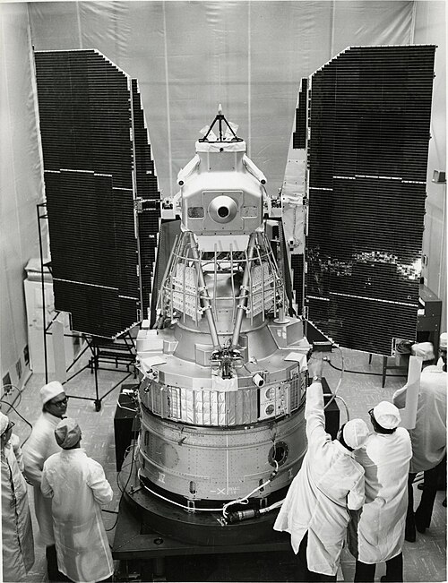
Landsat 1 carried both a Return Beam Vidicon camera system and a Multispectral Scanner designed by Virginia Norwood at Hughes Aircraft Company. The camera was expected to be the principal instrument, while the scanner was still considered experimental. Soon after launch, however, an electrical problem threatened the camera equipment. Operators stopped using the Return Beam Vidicon to protect the spacecraft. That decision reversed the intended hierarchy. The less familiar scanner remained available and delivered the observations that investigators preferred, turning an engineering contingency into the mission’s defining result without changing the satellite’s overall land-observation purpose.
Norwood’s scanner measured reflected energy in four spectral bands spanning visible and near-infrared wavelengths. Those separate bands converted a landscape into digital measurements that analysts could combine, compare, and display in false color. Vegetation, water, exposed rock, burned areas, and developed land could produce distinct spectral responses even when a conventional view made them difficult to separate. The instrument did not provide the close detail of modern satellites, but it offered consistent measurement across a very wide area. Its success showed why digital spectral information could be more useful for systematic Earth study than a familiar camera image alone.

Repeated passes turn scenes into evidence
The value of Landsat 1 came from repetition as much as from any single scene. A July 25, 1972 image of the Dallas and Fort Worth area arrived only two days after launch. In its false-color presentation, vegetation appeared in red shades while urban or rocky surfaces appeared gray and white. The same system soon recorded an 81,000-acre fire in central Alaska while the fire was still active. One orbital view showed the reach of a remote event that was difficult to assess from the ground. These early examples demonstrated how spectral data and regional coverage could answer practical questions quickly.
Over the full mission, Landsat 1 acquired observations covering roughly 75 percent of Earth’s surface. Cloud, orbital limits, and the scanner’s ground resolution prevented the archive from becoming a seamless high-detail map, but its repeated swaths supported comparisons across time. Researchers could examine agricultural regions, forests, river systems, coasts, cities, geological features, and burn scars under the same four-band measurement framework. NASA organized a principal-investigator program with about 300 researchers, and the United States Geological Survey records that approximately one third came from outside the United States. The archive therefore became both a technical test and an international research resource.
A first mission establishes a durable method
NASA renamed ERTS 1 as Landsat 1 in January 1975, shortly before the next spacecraft entered the program as Landsat 2. The new name connected the experimental mission to an ongoing series rather than a single technology demonstration. Landsat 1 continued operating until January 6, 1978, far beyond its planned one-year lifetime. NASA reports that its scanner collected more than 175,000 scenes during about five and a half years in orbit. In 1976, its observations also identified a small island off Canada’s eastern coast that became known as Landsat Island, another illustration of how repeated coverage could expose features overlooked from other viewpoints.
The first satellite’s long-term importance lies in the method it proved workable. Measurements were gathered from a predictable orbit, separated into spectral bands, processed as digital data, distributed for research, and retained for comparison with later observations. NASA developed and operated the spacecraft, while the United States Geological Survey processed, archived, and distributed land information. That institutional partnership supported continuity after Landsat 1 left service. Later instruments improved resolution and expanded the number of bands, but the organizing principle remained recognizable: observe broad land areas consistently, preserve the measurements, and let changes become visible through a record extending across missions and years.
Timeline: The United States launches Landsat 1
- July 23, 1972 ERTS 1 launches from Vandenberg Air Force Base with camera and scanner systems.
- July 25, 1972 The first orbital observations arrive, including a scanner scene of Dallas and Fort Worth.
- January 14, 1975 NASA announces that ERTS 1 will be known as Landsat 1.
- 1976 Mission imagery identifies the small feature later named Landsat Island.
- January 6, 1978 Landsat 1 is taken out of service after more than five years.
Related on thisDay
Cite this page
“Why Did Landsat 1’s Experimental Scanner Outlast Its Main Camera?” thisDay, thisday.info/history/landsat-1-1972/. Accessed 19 Oct. 2026.
Why Did Landsat 1’s Experimental Scanner Outlast Its Main Camera? (n.d.). thisDay. Retrieved October 19, 2026, from https://thisday.info/history/landsat-1-1972/
“Why Did Landsat 1’s Experimental Scanner Outlast Its Main Camera?” thisDay. Accessed October 19, 2026. https://thisday.info/history/landsat-1-1972/.